Thursday, November 22, 2012

Chapter 18

Well, guys, this is where we part ways. This is our final blog post. 

To close out the blog, we are going to talk about Hawaii! Our post is centered around Chapter 18 of the book  "Regional Landscapes of the United States and Canada" by Stephen Birdsall. 

Birdsall writes, "Today, nearly one Hawaiian  worker in four is a military employee. Military personnel and their dependents represent more than 10 percent of Hawaii's population."

Pittsburgh has the only museum in the country that honors women and men of all branches in the military. The museum is called Soldiers and Sailors Memorial Hall and Museum.

The address is: 4141 Fifth Avenue
Pittsburgh, PA 15213

(Credit: Museum's website).

Chapter 16

Today we will discussing Chapter 16 of the book "Regional Landscapes of the United States and Canada" by Stephen Birdsall.  And the chapter is about the North Pacific Coast. See below for a map of the states we are discussing. This map is from the US State Department.

As you can see, this chapter covers the North Pacific Coast including Alaska, Canada, Washington, Oregon and some of California.

Seattle, Washington, is home to Microsoft. In King County, Microsoft has 16,000 employees.

Pittsburgh is home to Heinz Corporation. Hence, the Steelers' stadium is Heinz Field. (Although, who else likes to think it's named after the beloved Hines Ward?) Heinz makes a lot of products including Heinz ketchup. Heinz is in 200 countries. They sell 650 million bottles of ketchup every year. In total they have 32,000 employees.

(From Heinz's site)

I'm not much for ketchup, but if I were, I'd be supporting Pittsburgh's best.

Chapter 15

Today's topic is Chapter 15 of the book "Regional Landscapes of the United States and Canada" by Stephen Birdsall.  And the chapter is about my home state, California!

Birdsall refers to California as "a state of immigrants." (p. 315) He says, "Although more than two-thirds of native-born Americans live in their state of birth, fewer than half of Californians were born in the state."

Pittsburgh, however, is home to many international immigrants. Pittsburgh's culture is defined by many cultures as many immigrants have settled there. Before 1900, people from Britain, Germany and Scandinavia settled in Pittsburgh. Luckily, there were no major clashes between native and foreign born people. After 1900, because of Pittsburgh's need for labor, people from Slavic Europe, the Baltic States and southern Europe came to Pittsburgh. Unfortunately, this caused some problems between the groups living in Pittsburgh. Those already in Pittsburgh thought "their social standings, customs, and lifestyles were in jeopardy to what they believed were the invading newcomers."

Chapter 14

Welcome back to my blog. Today we are talking about Chapter 14 of the book "Regional Landscapes of the United States and Canada" by Stephen Birdsall. The Chapter is about the Southwest Border Area: Tricultural Development. Look at the map below for a picture of where we are talking about. The picture is from a Santa Barbara Blog.

As you can see from this map, included in this region is California, Arizona, New Mexico and Texas.

If you live in this region like I do, you know that illegal immigration is a hot topic. Birdsall writes, "Large numbers of illegal immigrants make it difficult to estimate how many Mexicans enter the United States each year ... estimates  of 2 to 12 million." (p. 282)

Is illegal immigration a problem in Pittsburgh? Let's look at Pennsylvania as a whole. I'm getting this information from an article from the Pittsburgh Post-Gazette by policy analyst Daniel Griswold.

According to the paper, illegal immigration is not a problem. Illegal immigrants are only 1.3% of the population and that's 40th in the country. The article even says cracking down on illegal immigration is the wrong answer because it would hurt the economy because "low-skilled immigrants do not compete directly with the large majority of American workers."

Chapter 13

Welcome back to my blog. Today we are talking about Chapter 13 of the book "Regional Landscapes of the United States and Canada" by Stephen Birdsall. The Chapter is about the Empty Interior. Look at the map below for a picture of where we are talking about. The picture is from the US Embassy in Japan's website.

As you can see, included in this region is Alaska, parts of Canada (Yukon and British Columbia), Washington, Oregon, California, Nevada, Idaho, Utah, Arizona, New Mexico, Texas, Colorado and Wyoming.

Birdsall writes, "The Empty Interior is a land of stark contrast where aridity and lushness intermingle across wide desert valleys and high, rugged mountains." (p. 252)

Pittsburgh is home to Mount Washington, which overlooks the city. In fact, USA Today voted the view from Mount Washington the second most beautiful place in the US. (As someone who has been there, I would agree.) From Mount Washington, you can see a view of the city, including the view of the rivers and the confluence (where the Allegheny and Monongahela form the Ohio River) and the city's skyline.

There are two inclines that go up Mount Washington. (If you scroll down this blog enough, you will see photos of my trip on the the incline and of the incline.) Here is a cool video of one of the inclines going up Mount Washington.


(Unfortunately, this video was taken during the day. If you ever go, I highly suggest going during the night. Much more breathtaking.)

But Mount Washington isn't really a "high, rugged mountain." It's only 367 feet! I guess we can say Pittsburgh is different from the Empty Interior in that way. But it's an important part of Pittsburgh for tourism reasons and it used to be the site of many coal mines. It was even called Coal Hill.

Chapter 12

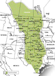
So glad you came back! Today, we are talking Chapter 12. The chapter is entitled "The Great Plains and Prairies." You can find the chapter in the book, "Regional Landscapes of the United States and Canada" by Stephen Birdsall. 


Photo Credit: US Embassy in Japan.

This region is know for its extreme weather. The plains have a twenty year drought cycle. In July, Pittsburgh also had drought like symptoms. Check out this article from the Post-Gazette for more. In the summer, the weather was very hot with not enough moisture, which has an impact on crops. The Post-Gazette quoted a meteorologist:


"The drought conditions are accelerating," said David Miskus, a meteorologist at the National Weather Service's Climate Prediction Center in Washington, D.C told the Post- Gazette
Other states, such as states in this region like Oklahoma and Kansas, were also experiencing droughts this Summer.

Another meteorologist quoted by the Post-Gazette said it was the worst drought since 1988.

Chapter 11

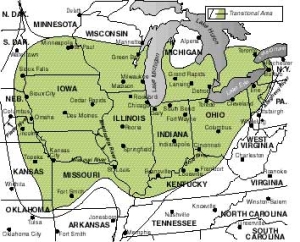
Welcome back to my blog. Today, we are talking about Chapter 11. The chapter is entitled "The Agricultural Core." You can find the chapter in the book, "Regional Landscapes of the United States and Canada" by Stephen Birdsall. 

(Photo credit: The US Embassy)

As you can see from the picture, Pittsburgh just misses being in this region. As they say, so close, but no cigar. It may be hard to see, but the Ohio river is in this region and the Ohio river starts in our favorite place, Pittsburgh. The two rivers Allegheny and the Monongahela rivers turn into the Ohio river. Now, I mentioned the rivers briefly in Chapter 3, but for Chapter 11, I'd really like to focus on the Ohio River.

There's a lot more than how long (more than 900 miles) the river is.  The river has been dubbed "The Beautiful River" and "The Great River."  The river also has significance in our history. In the 1600s and 1700s, the river was the boundary in the Northwest Territory and showed which side was the English and which side was the Native American territory. Some of America's first permanent settlements were formed on the Ohio River's banks, including Cincinnati, home of the Bengals, one of the Pittsburgh Steelers' rivals. From the 1800s to now, the River has been key to transporting goods.

Here's a video of a ferry ride on the Ohio River in Pittsburgh. It reminds me of my time in the magical city.
In the video, you can see PNC Park. My friend recently saw a Pirates game when she was in this Pittsburgh. Here you can see a view of the Ohio river from her seat.


Chapter 10

Welcome back! It's been a long time since we last talked, but we are covering some interesting material today. We will begin with Chapter 10 of the boo "Regional Landscapes of the United States and Canada" by Stephen Birdsall.  

Chapter 10 talks about the Southern Coastlands. This region includes all of Florida as well as part of Texas, Louisiana, Mississipi, Alabama, Georgia and South Carolina.

Florida is of course known for its oranges. My grandparents send me mine every year. According to Birdsall, Florida has seven major citrus fruits. Orange and grapefruit are the best. In fact, Birdsall writes, "Orange production increased steadily until 1978, where 7.4 million tons were harvested." (p. 192)


What more information on Florida's oranges? Check out the juicy oranges details and the rivalry between California and Florida. Click on this article from Pittsburgh magazine!

"Florida’s crop of thin-skinned, juicy fruit is distinctive from the thick-skinned, easily segmented oranges grown in California, which emerged as Florida’s citrus rival,"  Kate Chynoweth writes.

What do you think? I like Florida's better, don't you? Leave a message in the comments!


While Pittsburgh may import oranges from the Sunshine State, they do have what they call "urban farms." And they were a hot topic back in 2010. Pittsburgh Tribune has the story:

"Just as urban beekeeping, community gardening and raising poultry gains traction across the country, Pittsburgh leaders are considering limiting such agricultural practices."

Many urban farmers were not pleased. They started a Facebook group to protect urban farming and many urban farmers started a discussion on the population chicken site, Backyard Chickens.

WDUQ, Pittsburgh's radio station's blog gives a follow up:
Pittsburgh residents are able to keep their farms with their plants and their bees and chickens. They will have to pay a $300 fee and if they are going to have animals, they will need additional permits.

What do you think of Pittsburgh's urban farming decision? Post in the comments! 


Wednesday, October 10, 2012

Chapter 9

Today we are talking about Chapter 9 of the boo "Regional Landscapes of the United States and Canada" by Stephen Birdsall.  

Chapter 9 is called the Changing South. Included in this region is Virginia, North Carolina, South Carolina, Georgia, Florida, Alabama, Kentucky, Tennessee, Mississippi, Louisiana, Texas, Arkansas, Illinois and Missouri.

The book talks about "Pittsburgh Plus." Pittsburgh's United States Steel Company inflicted a new Pricing Policy. Birdsall writes, "Under this company policy, consumers of Alabama Steel paid the price of steel at Pittsburgh plus $3.00 per ton ($2.72 per metric ton) plus regular freight costs from Birmingham." This way it was cheaper for Atlanta firms to order steel from Pittsburgh. (p. 175)

Basically, the US Steel company made this "discriminatory policy" against TCI's Steelworks in Alabama after famous banker J.P. Morgan, who owned the US Steel Company, took control of TCI in 1907. The US Steel officials did not want to compete with TCI so they made it impossible for TCI to compete with them.

Chapter 8

Today we are talking about Chapter 8 of the boo "Regional Landscapes of the United States and Canada" by Stephen Birdsall.   Chapter 8 talks about the Appalachia and the Ozarks. Included in this region are parts of Oklahoma, Missouri, Arkansas, New York, Pennsylvania (not Pittsburgh), West Virginia, Ohio, Kentucky, Tennessee, Alabama, Georgia, South Carolina, North Carolina, Virginia and Maryland. A lot states are included, but not all of the land in each states applies to this region.

Birdsall writes, "Appalachia's population is conservative, both politically and religiously." (p. 152)

In the 2004 election, John Kerry won Pittsburgh and the Pittsburgh suburbs, by 15 points. The last time a Republican Presidential Candidate won Pennsylvania was in 1988, but George H. W. Bush did not have a good performance in Pittsburgh.


Chapter 7


Today we are talking about Chapter 7 of the boo "Regional Landscapes of the United States and Canada" by Stephen Birdsall.  (Note: We skipped Chapter 6 because it was about Canada and this is a US Geography course.)

Chapter 7 is about the Bypass East. The Bypass East includes some of Canada as well as the US. Included in this chapter is New York, Vermont, New Hampshire, Maine and some of Canada such as Nova Scotia and Prince Edward Island.

Birdsall writes on p. 133, "The Bypassed East is no place for people who want a dry, warm climate. It is a place where polar, continental and maritime weather systems meet."

So, let's talk a little about Pittsburgh's climate:
Pittsburgh's climate gets a little hot in July (average high 82.7 degrees F), but in the winter it gets cold. In January, the average high is  35.1 degrees F. 

"Almost all of the region [Birdsall is taking about the Bypass East] receives substantial and evenly distributed precipitation, usually between 100 and 150 centimeters (40 to 60 inches) annually and spread throughout the year," Birdsall adds. (p. 133)

Pittsburgh has rain throughout the year. From data from 1971-2000, the month with the least rain is October (2.25 inches) and the month with the most is June (4.12). The average number of inches a year is 37.85. So the Bypass East could theoretically get more inches than Pittsburgh.

Monday, October 8, 2012

Chapter 5

Today we are talking about Chapter 5 of the boo "Regional Landscapes of the United States and Canada" by Stephen Birdsall. 

First, to brighten your day up, I've posted a picture of our favorite place, Pittsburgh. This photo belongs to my friend and is used with permission.


Ah, such a nice day in Pittsburgh. Soon it will get cold and snowy.

Chapter 5, called the North American Manufacturing Core talks about Pittsburgh. How exciting! The North American Manufacturing Core includes some parts of the following states: Wisconsin, Illinois, Indiana, Michigan, Indiana, Ohio, Pennsylvania, Maryland, Delaware, New Jersey, Connecticut, Rhode Island, Massachusetts, New York, Vermont and New Hampshire. 

But who cares about all of those other states. Let's just focus on Pennsylvania's Pittsburgh.

The book states, "At the end of 2006, Pittsburgh's unemployment was 4.9 percent compared to 7.2 percent for the Detroit metro area." (p. 105)

But, unfortunately, the recession hit in 2008 and now unemployment nationwide is 7.8. (Bureau of Labor and Statistics). However, it is a little lower in Pittsburgh. The rate is 7.5 percent.

The unfortunate news is the rate is 2.9% higher than it was 6 years ago.

Chapter 4

Today we are talking about Chapter 4 of the boo "Regional Landscapes of the United States and Canada" by Stephen Birdsall. 

Chapter 4 talks about Northeastern United States. In the book, they call it the Megalopolis. Included are parts of New Hampshire, Rhode Island, Connecticut, parts of New York, New Jersey, Delaware, Maryland, Washington D.C., some of Virginia and finally, some of Pennsylvania. But although we do talk about Pennsylvania in this chapter, it does not include Pittsburgh. Pittsburgh is in Western PN and we are talking about eastern PN, which includes the state's capital, Harrisburg and the historical city of Philadelphia.

The book states, "Ten of the country's 46 Metropolitan areas exceeding 1 million people in 2000 were located in the Megalopolis." (p. 66)

The US Census Bureau has a link to the Annual Estimates of the Population of Metropolitan areas from April 1, 2010 to July 1, 2011. If you click a link, go to "Annual Estimates of the Population of Metropolitan and Micropolitan Statistical Areas: April 1, 2010 to July 1, 2011" and click XLS to access the information I'm about to tell you. But if you click XLS, the information will load in Excel.

In the Excel document, the population estimates for 2011 are 2,359,746 people.

But I know what you're thinking, Maddy, the book was talking about the year 2000. Why are you giving me information for 2011. Well, I think it's important to have up to date information. Isn't that the point of a blog?

Let's back-up and look at data from 12 years ago, just like data our textbook cited. (Remember the book came out in 2009 -- before the 2010-11 census data came out.) For this, we are going to this link (also on the US Census site.) From there, click Table three (Metropolitan Areas Ranked by Population: 2000)'s excel document. The nice thing about this document is it has the most populated areas in order. Pittsburgh is 22nd biggest metropolitan place in the US (2,358,695 people). Some of the cities in the Megalopolis that beat Pittsburgh were NYC (1st) and Philadelphia (6th). Pittsburgh did beat Hartford, CT (came in at 42).

Not that much of a difference in 11 years, is it?

What's the point of this post? How do Pittsburgh relate to the Megalopolis? Well, we are comparing Pittsburgh's Metropolitan area to the Megalopolis. As you can see, Pittsburgh's metropolitan area is similar to Megalopolis' area

Monday, September 3, 2012

Chapter 3

Today we are talking about Chapter 3 of the book  "Regional Landscapes of the United States and Canada" by Stephen Birdsall. 

Birdsall mentioned our city twice this chapter. The first mention is that Pittsburgh is located next to navigable water. Pittsburgh has three rivers in it (Hence, the Steelers' old stadium, Three Rivers Stadium). The Allegheny and the Monongahela rivers form the Ohio River (this is called the Three Rivers confluence.) Interesting facts about these rivers:

--The Allegheny River starts north-central Pennsylvania, goes into northwest New York and then back into  Pennsylvania. The river is 325 miles.
--The  Monongahela River goes fronorth central West Virginia through western Pennsylvania to Pittsburgh. It's 127 miles.
--The Ohio River starts in Pittsburgh and ends in Illinois. This river is 981 miles long!

The book also talks about how American English language is different in each region. In Pittsburgh, a sandwich is a Hoagie. Well if you want a Hoagie, you have to stop at Primanti Bros. They make the best Hoagies in town! They put fries in your hoagie.

Chapter 2

Welcome back to my blog. Today we are discussing Chapter two of the book "Regional Landscapes of the United States and Canada" by Stephen Birdsall. There will be a science lesson and a history lesson, but first let's recap the text book.

The book has a map of Major Coal Mining Fields (p. 36) and Pittsburgh is on it.  The type of coal? Bituminous."North America is favored with abundant mineral fuel resources," The author writes on page 35. "The two countries (US and Canada), however, have a large demand for fuels, which generates a constant search for new resources." 

First, let's discuss what "Bituminous" means. Bituminous has no real shape and is dark colored. It has the properties of cement, is made of high molecular weight hydrocarbons and can be dissolved in carbon disulfide.  (That's the end of the science lesson.)

Now that the science lesson is over, let's move to the history lesson. The Bituminous coal was first mined on Mount Washington. (If you read below, you'll see pictures of the Mount Washington incline -- if you ever go to Pittsburgh, you need to take the incline). By 1830, Pittsburgh used more than 400 tons of coal a day. The need for coal expanded as the West and Steel Production grew. In the past 200 years,  more than ten billion tons of coal has been mined in 21 counties in Pennsylvania. 

And it's a good thing Pittsburgh has coal, because coal is important for steel production.  (According to World Coal, "68% of total global steel production relies directly on inputs of coal.") You'll learn more about Pittsburgh's steel production below.

There are a lot of cool historical photos of Pittsburgh's coal mining industry. Click here to access them.

Friday, August 31, 2012

Chapter 1 Continued

My last post was a post about the Steel Industry in Pittsburgh. That post was covering Chapter 1 of the Assigned Textbook. Naturally, you'd think this is Chapter 2, but instead it's a special post (a supplement of Chapter 1, if you will.)

My Grandfather, Richard Pumilia, was in the steel business for 41 years.  Now if you haven't read my last post, Pittsburgh was known for its Steel Production. So, as you can imagine, my grandfather knows a lot about Pittsburgh and its many mills. Let's hear what he had to say about Pittsburgh's Steel Production ...


"The one big mill that dominated the landscape in the 50's was J&L's Southside works on both sides of the river right in town. It was a huge sprawling plant that was important for the economy but also contributed to the characterization of Pittsburgh as the 'Smoky City.'

By the early 60's they had done a good job of improving their pollution control throughout the entire area. By the mid 80's it was all gone, cleared and redeveloped. "-- Richard Pumilia, August 31st, 2012

So, there you have it, first hand knowledge about the history of Steel in Pennsylvania. 

Tuesday, August 28, 2012

Chapter 1

Steel, Steel, Steel!

Pittsburgh is known as the Steel City. 


Today's Blog Post is about Chapter 1 of the Book "Regional States of the United States and Canada" by Stephen Birdsall.  The book talks about Resource Abundance and Resource Dependence. The United States is the leading export for wheat, corn, rice and coal. 


Let's talk a little more about America's Steel town. The Steel Mills on the Allegheny and Monongahela Rivers are no longer there. However, Pittsburgh still is the place for 25% of America's Steel Providers.


NPR did a story about the closing of the steel mills, but the report tells listeners that the Industry is still alive.


"It was like going to a funeral," One man said of the Steel Mills closing.


Check out their story here.


University of Pittsburgh has a huge collection of historical Pittsburgh -- including pictures of the old steel mill.


Here's a video of Steel being made right here in Pittsburgh! In this video, iron is turned into steel.  Up to 250 tons of Steel can be made in less than 45 minutes.


Interested in buying the book about the book we'll be discussing in this blog? Here it is on Amazon.

Monday, August 27, 2012

Introduction

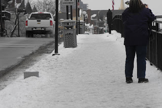
I've attached some pictures of Pittsburgh. These photos are original. They were taken January of 2008 when I visited for the Pittsburgh Steelers' AFC Championship game against the Baltimore Ravens. Note the snowy weather, the mountains and the Three Rivers confluence (The Allegheny and the Monongahela rivers form the Ohio River.) Pittsburgh is blessed with some interesting geography. In addition, Pittsburgh is known for its steel production, hence the Steelers' name. Bridges and buildings have been built all around the city as well as Heinz Field, the Steelers' Stadium, the Pittsburgh Penguins Arena and the Pittsburgh Pirates' Stadium. Pittsburgh also has an incline built on the mountain that overlooks the city.
A picture of a mountain with the incline on it.

Pittsburgh's skyline, a bridge and one of Pittsburgh's rivers.
 Just a snowy day in Pittsburgh!
Another shot of Pittsburgh's rivers and buildings.

 The Pittsburgh confluence.
A look down Pittsburgh's mountain, with the incline and river visible.